Geometries
In Db2® Spatial
Extender, the operational definition of geometry is a model of a geographic
feature.
Webster's Revised Unabridged Dictionary defines geometry as That
branch of mathematics which investigates the relations, properties,
and measurement of solids, surfaces, lines, and angles; the science
which treats of the properties and relations of magnitudes; the science
of the relations of space.
The word geometry has
also been used to denote the geometric features that, for the past
millennium or more, cartographers have used to map the world. An abstract
definition of this new meaning of geometry is a point or aggregate
of points representing a feature on the ground.
In Db2 Spatial Extender, the model can be expressed in terms of the feature's coordinates. The model conveys information; for example, the coordinates identify the position of the feature with respect to fixed points of reference. Also, the model can be used to produce information; for example, the ST_Overlaps function can take the coordinates of two proximate regions as input and return information as to whether the regions overlap or not.
The coordinates of a feature that a geometry represents are regarded as properties of the geometry. Several kinds of geometries have other properties as well; for example, area, length, and boundary.
OpenGIS Simple Features Specification for SQL. Seven members of the hierarchy are instantiable. That is, they can be defined with specific coordinate values and rendered visually as the figure shows.
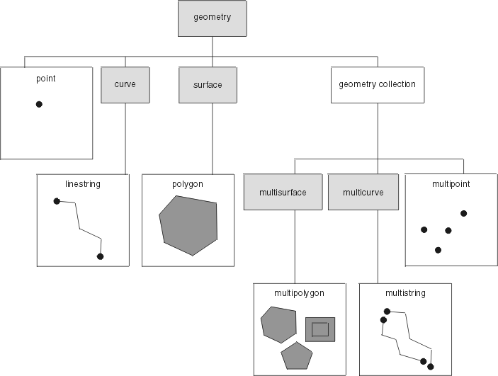
The spatial data types supported by Db2 Spatial Extender are implementations of the geometries shown in the figure.
As the figure indicates, a superclass called geometry is the root of the hierarchy. The root type and other proper subtypes in the hierarchy are not instantiable. Additionally, users can define their own instantiable or not instantiable proper subtypes.
The subtypes are divided into two categories: the base geometry subtypes, and the homogeneous collection subtypes.
- Points
- A single point. Points represent discrete features that are perceived as occupying the locus where an east-west coordinate line (such as a parallel) intersects a north-south coordinate line (such as a meridian). For example, suppose that the notation on a world map shows that each city on the map is located at the intersection of a parallel and a meridian. A point could represent each city.
- Linestrings
- A line between two or more points. It does not have to be a straight line. Linestrings represent linear geographic features (for example, streets, canals, and pipelines).
- Polygons
- A polygon or surface within a polygon. Polygons represent multisided geographic features (for example, welfare districts, forests, and wildlife habitats).
- Multipoints
- A multiple point geometry collection. Multipoints represent multipart features whose components are each located at the intersection of an east-west coordinate line and a north-south coordinate line (for example, an island chain whose members are each situated at an intersection of a parallel and meridian).
- Multilinestrings
- A multiple curve geometry collection with multiple linestrings. Multilinestrings represent multipart features that are made up (for example, river systems and highway systems).
- Multipolygons
- A multiple surface geometry collection with multiple polygons. Multipolygons represent multipart features made up of multisided units or components (for example, the collective farmlands in a specific region, or a system of lakes).
As their names imply, the homogeneous collections are collections of base geometries. In addition to sharing base geometry properties, homogeneous collections have some of their own properties as well.
Properties of geometries
- The type that a geometry belongs to
- Geometry coordinates
- A geometry's interior, boundary, and exterior
- The quality of being simple or non-simple
- The quality of being empty or not empty
- A geometry's minimum bounding rectangle or envelope
- Dimension
- The identifier of the spatial reference system with which a geometry is associated